
In the pitch-black environment of an Arctic winter, where the sun may not rise for weeks and heavy cloud cover perpetually masks the surface from traditional optical satellites, a Russian ballistic missile submarine quietly slips away from its berth at the Gadzhiyevo Submarine Base. Simultaneously, thousands of miles away in the Mediterranean, a small vessel maneuvers at 15 miles per hour, its identification transponders intentionally silenced. Nearby, a tanker drifts alongside another vessel in a "ship-to-ship" transfer, a common tactic used to obfuscate the origin of sanctioned oil. These activities, once shielded by the vastness of the ocean and the limitations of orbital photography, are now being brought into sharp focus by a new era of persistent radar surveillance.
Iceye, the Finland-based Earth Observation (EO) powerhouse, has successfully demonstrated the ability to track these high-stakes maritime maneuvers through its expansive constellation of synthetic aperture radar (SAR) satellites. As the world’s largest operator of SAR technology, Iceye is redefining maritime domain awareness by providing high-revisit data that ignores the constraints of daylight and weather. According to internal application studies and recent reports, the firm’s ability to monitor "dark" vessels—those that have disabled their Automatic Identification Systems (AIS)—has become a critical asset for Western intelligence, defense agencies, and commercial regulators.
The Technological Advantage of Synthetic Aperture Radar
The fundamental challenge of maritime monitoring lies in the environment itself. Approximately 70% of the Earth’s surface is covered by clouds at any given moment, and half of the planet is always in darkness. Traditional optical satellites, which function essentially like high-powered digital cameras, are rendered ineffective by these conditions. SAR technology, however, operates by emitting microwave pulses and measuring the signal that bounces back from the Earth’s surface. Because these microwaves penetrate clouds, smoke, and darkness, SAR provides a reliable, 24/7 monitoring capability.
Eric Jensen, CEO of Iceye US, emphasized that the density of the company’s constellation is its primary competitive advantage. With the recent addition of six satellites launched during SpaceX’s Transporter-16 rideshare mission in early 2026, Iceye now operates 70 satellites in orbit. This volume allows for "high-revisit" rates, meaning the same geographical coordinate can be imaged multiple times per day, and in some high-latitude regions, several times per hour.
"In areas with high cloud cover or short daylight, monitoring ships is made possible only by their obligation to transmit their locations," Jensen stated. However, when vessels intentionally stop transmitting or use "VPN" techniques to spoof their GPS coordinates to a different location, the only way to verify the truth is through radar-based collection. The density of the Iceye constellation ensures that there is almost always a satellite in position to catch these discrepancies in near real-time.
Strategic Surveillance: The Northern Sea Route and Murmansk
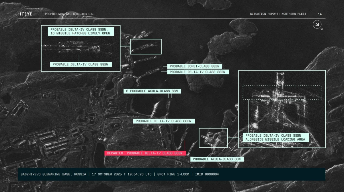
One of the most critical theaters for Iceye’s technology is the Northern Sea Route (NSR). As climate change accelerates the melting of Arctic sea ice, this seaway—connecting the Barents Sea to the Bering Strait—has become an increasingly viable commercial corridor. For Russia, the NSR represents a strategic priority for both energy exports and naval maneuvering. However, the route’s extreme environment, characterized by months of total darkness and frequent storms, makes it an ideal setting for "nefarious ambitions," according to Jensen.
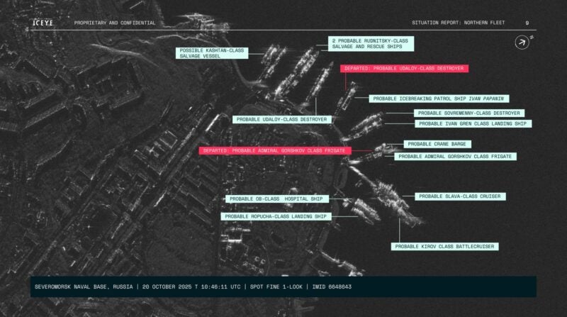
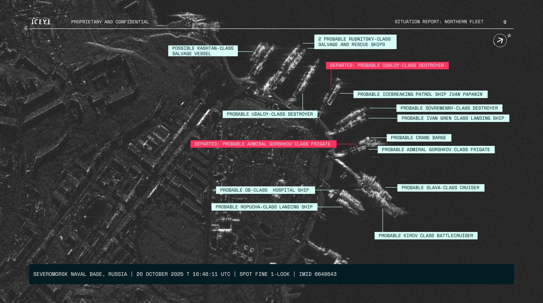
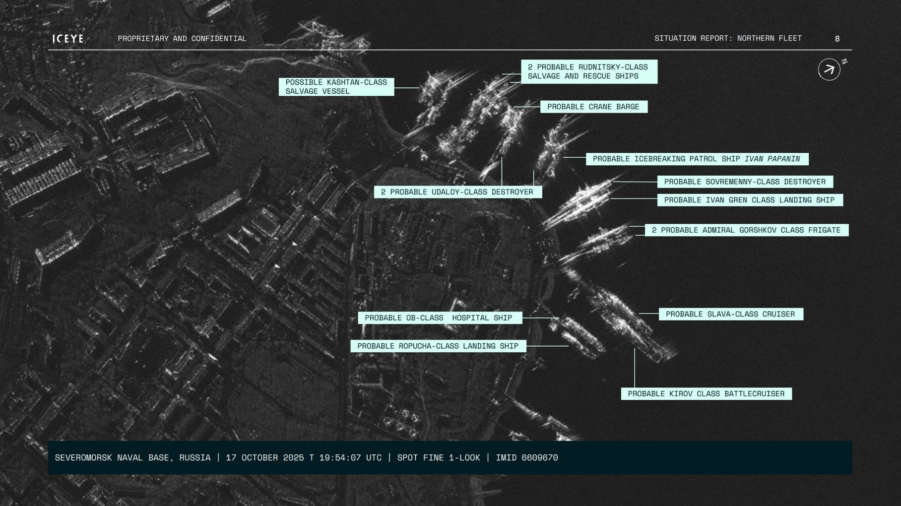
An internal situation report provided by Iceye illustrates the company’s surveillance of the Severomorsk Naval Base in Murmansk, a vital hub for the Russian Northern Fleet. Over a nine-day period in October 2025, Iceye’s SAR sensors captured a series of high-resolution images that flagged the departure of significant naval assets, including what analysts identified as an Admiral Gorshkov-class frigate and an Udaloy-class destroyer.
The ability to track such movements is invaluable for NATO and Western allied nations. In a region where visibility is traditionally low, Iceye’s sensors provide a "truth layer" that allows nation-states to enforce sanctions and monitor military escalations. Jensen noted that the Northern Sea Route is prime for illegal shipping because of its environmental opacity, a gap that Iceye is now closing.
Combatting the Shadow Fleet and Sanction Evasion
Beyond military movements, Iceye’s constellation is being deployed to combat the "shadow fleet"—a network of aging tankers used by sanctioned states to transport oil and gas. These vessels often engage in illicit ship-to-ship transfers in international waters to hide the origin of their cargo.
A notable incident in 2022 highlighted this capability when Iceye satellites detected an unauthorized transfer near the Strait of Taiwan. Despite the vessels attempting to hide their activities, the SAR imagery provided definitive proof of the encounter. Jensen noted that while the satellites might not initially know exactly what is being transferred, they can identify that two ships from sanctioned jurisdictions are interacting, providing decision-makers with the "confidence to respond."
Under International Maritime Organization (IMO) regulations, large ships are required to broadcast their location via AIS to prevent collisions and ensure safety. However, the rise of geopolitical tensions has led to a surge in AIS "darkness." Iceye’s ability to cross-reference AIS data with actual radar imagery allows authorities to identify "dark targets"—vessels that are physically present on the water but absent from digital tracking screens.
Chronology of Growth and Institutional Trust
Iceye’s rise to a $2.8 billion valuation has been marked by rapid scaling and a series of strategic milestones:
- 2022: Iceye begins providing critical SAR data to the Ukrainian government following the Russian invasion. This partnership was bolstered by a fundraising effort in Ukraine that allowed the country to purchase full access to one of Iceye’s satellites, significantly enhancing its intelligence-gathering capabilities at night and through cloud cover.
- December 2025: The company closes a $173 million funding round. This capital injection was earmarked for expanding production and further developing its high-revisit constellation.
- January 2026: Iceye expands its formal services to Ukraine, integrating more deeply with Western-aligned defense strategies to monitor Russian logistics and troop movements.
- March 2026: The launch of six additional satellites on the SpaceX Transporter-16 mission brings the total operational constellation to 70.
- April 2026: Iceye releases case studies demonstrating the tracking of Russian naval assets in the Arctic, solidifying its role as a premier provider of maritime intelligence.
The company’s client list now includes the U.S. Army, the National Reconnaissance Office (NRO), NASA, and various humanitarian organizations. This diverse portfolio underscores the dual-use nature of SAR technology, serving both high-level national security missions and civilian needs.
Broader Implications: From National Security to Disaster Relief
While defense and intelligence remain the primary drivers of Iceye’s revenue, the company is increasingly focusing on the humanitarian and insurance sectors. The same technology used to track a destroyer in the Arctic can be used to map the extent of flooding during a hurricane.
Jensen cited Iceye’s work following Hurricanes Milton and Helene in 2024. During these disasters, SAR satellites provided emergency responders with precise maps of flooded areas, even while the storms were still raging and traditional aircraft were grounded. The goal for the near future is to reduce the "latency" of this data—the time between an image being taken and it reaching the end-user.
"We don’t have to go through this chain where it takes hours and hours and hours, potentially days, to give people information," Jensen said. "We could potentially do it in minutes."
The integration of modern computing and AI-driven analysis is expected to further accelerate this process. By automating the detection of ships or floodwaters, Iceye aims to provide actionable insights rather than just raw imagery. This shift from "data provider" to "intelligence provider" is a key component of the company’s long-term strategy.
Analysis of the Earth Observation Market
Iceye’s success reflects a broader shift in the Earth Observation market. Historically, high-quality satellite imagery was the exclusive domain of superpowers. Today, commercial firms are providing data that often rivals or exceeds the capabilities of government-owned systems. This "democratization" of space-based intelligence has profound implications for global transparency.
The $2.8 billion valuation of Iceye indicates strong investor confidence in the persistence of geopolitical volatility. As long as nations seek to bypass sanctions and move military assets in secret, the demand for unblinking, all-weather surveillance will continue to grow. Furthermore, the increasing feasibility of the Northern Sea Route ensures that the Arctic will remain a focal point of maritime friction, placing Iceye’s technology at the center of 21st-century geopolitics.
As Iceye continues to expand its constellation, the oceans are becoming smaller. The "dark" corners of the globe, once protected by the shroud of night and the veil of clouds, are now under constant watch. For the operators of sanctioned tankers and the commanders of Arctic submarines, the era of operating in the shadows is rapidly coming to an end.