
The rapid evolution of artificial intelligence, initially characterized by the dominance of large language models (LLMs) powering text-based predictive, generative, and agentic services, is now expanding into a more nuanced understanding of the physical world. Beyond text, large image/vision models and large audio models have paved the way for a burgeoning field of video generation. However, the next significant leap in AI capabilities is emerging in the domain of spatial intelligence, aiming to equip AI systems with the ability to comprehend and reason about physical environments, moving beyond the confines of digital representations. At the forefront of this paradigm shift are "large geospatial models" (LGMs), a new class of foundation models designed to construct geometrically accurate, machine-readable models of real-world spaces. These models are built upon a rich tapestry of data, including 3D scans, satellite imagery, LIDAR, and GPS data, creating a robust foundation upon which developers can build a new generation of layered services.
Niantic Spatial Unveils Scaniverse for Businesses: A Gateway to Spatial Intelligence
Physical world mapping specialist Niantic Spatial has positioned itself as a key player in the ambitious endeavor to create a dynamic, living model of the world—one that is not only visually representative but also comprehensible and interactive for both humans and machines. This week, the company launched Scaniverse for businesses, a comprehensive software service engineered to serve as a primary entry point for spatial intelligence applications. This development signifies a critical step in democratizing access to advanced spatial understanding, moving it from specialized research into practical, commercial applications.
The inherent complexity of geospatial mapping and model development presents a significant challenge. Unlike text or image-based AI, which operates within well-defined digital datasets, understanding and modeling the physical world requires integrating diverse, often unstructured, real-world data. This necessitates a departure from traditional AI training methodologies.
Moving Beyond Text and Images: The Imperative for Geometric Accuracy
Niantic Spatial highlights that a fundamental limitation in current world modeling approaches stems from their reliance on text and image-based training data. While these methods have yielded impressive results in digital domains, they fall short when it comes to capturing the precise spatial relationships and geometric properties essential for interacting with the physical world. The company’s approach elevates this practice by leveraging technologies that generate models with exact coordinates and geometry, thereby ensuring environments are not only navigable but also interpretable by machines.
The significance of this advancement becomes clearer when considering the vast scope of global economic activity. John Hanke, Executive Chairman of Niantic Spatial, argues that the digital economy, while substantial, represents only a fraction of the world’s total economic output. He contends that AI systems trained exclusively on text and images are inherently limited in their ability to engage with and optimize the substantial portion of the global economy that operates outside of digital interfaces. This undigitized segment, Hanke emphasizes, encompasses the core activities that sustain human life and society.
The Undigitized 80%: Unlocking Economic Potential Through Spatial AI
In a recent post on the company’s blog, Hanke elaborated on this critical point, stating, "Just 20% of the world economy is online, but the 80% is not." He further articulated that this vast, offline economic sphere encompasses industries such as energy, agriculture, manufacturing, construction, transportation, and logistics. These sectors are fundamentally concerned with the "acts of extracting, refining, growing, assembling, combining, and shipping the atoms that warm us, shelter us, feed us, and generally make life possible for human beings." Hanke’s assertion underscores that these are not merely abstract digital processes but the very foundations of human existence, and AI systems that can effectively engage with them hold immense potential.
Hanke and his team at Niantic Spatial differentiate between merely capturing a space for digital representation and possessing an exact understanding of one’s position within that space. They posit that many existing solutions in the geospatial AI field address only one of these aspects. Niantic Spatial’s ambition is to bridge this gap by developing geometrically accurate and spatially grounded models that empower machines to understand and interact with the physical world in a comprehensive manner. This dual capability is crucial for enabling sophisticated applications that require precise environmental awareness.
Photorealism and Precision: The Power of Gaussian Splats
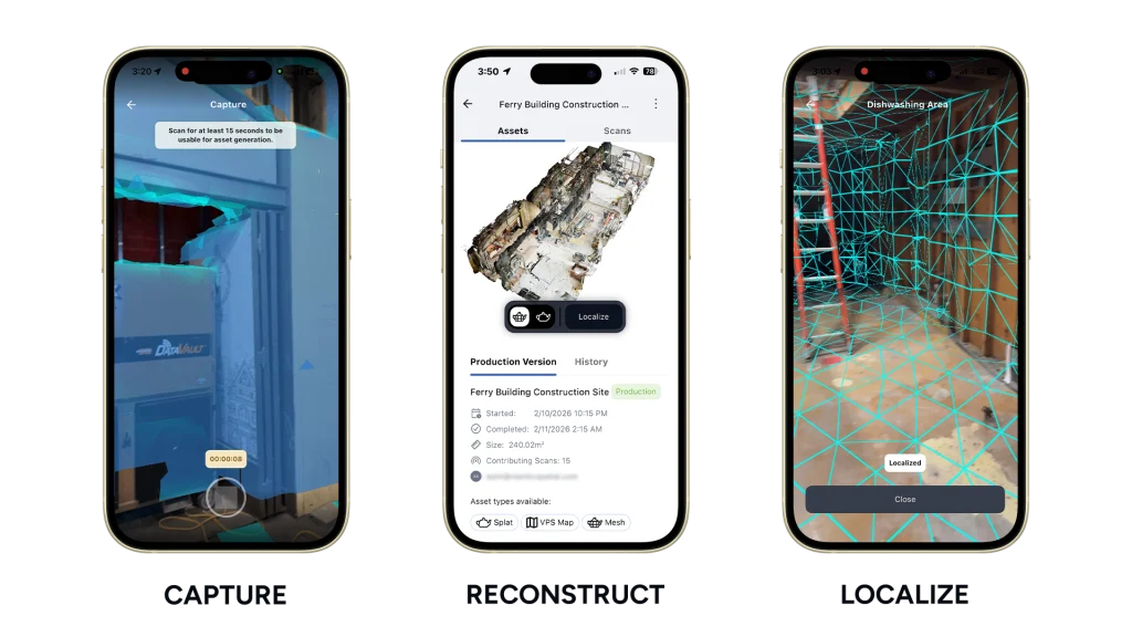
Scaniverse offers versatile capabilities for capturing physical spaces, accommodating anything from individual rooms to expansive areas spanning thousands of square meters. The software integrates with a web and mobile platform designed for capturing 3D spaces of all sizes using multiple devices. This process generates visual positioning maps and meshes, essential for spatial understanding. Furthermore, the technology produces Gaussian splats, an advanced 3D rendering technique that utilizes overlapping point-based rendering to create highly photorealistic digital representations of environments.

Scaniverse for businesses functions as a self-service platform, enabling teams to scan and reconstruct real-world environments using readily available technology like smartphones or 360° cameras. This includes diverse settings such as construction sites, warehouses, industrial facilities, and even underwater locations. The generated spatial maps are crucial for robots and AI agents that require accurate environmental data to navigate and operate effectively in the physical world.
Complementing Scaniverse is Niantic Spatial’s VPS 2.0 (Visual Positioning System), a newly enhanced service offering near-centimeter-level positioning accuracy within mapped environments. Crucially, it provides reliable positioning even in areas where traditional GPS signals are weak or unavailable. In locations mapped with Scaniverse, VPS 2.0 delivers highly accurate 6 Degrees of Freedom (6DoF) localization. In unmapped areas, it intelligently corrects GPS errors and dropouts, ensuring improved and dependable positioning and heading information, particularly in challenging GPS-degraded environments. This robust positioning capability is foundational for autonomous systems operating in complex physical spaces.
Lampata: Advancing Geospatial AI Through Earth Observation and GIS
In parallel, specialized geospatial AI services organizations are also making significant strides in this domain. Dean Summers, founder and director of engineering at Cambridge, UK-based Lampata, highlights that while the AI industry has historically been fixated on language, the next evolutionary leap will be driven by systems capable of understanding the world as it truly exists: spatially and dynamically.
Summers explains that "Foundational models built on Earth Observation (EO), GIS, and geospatial data are the logical next step, because they allow machines to reason over environments, assets, and change over time rather than just words on a page." He further elaborates that "This is where AI starts to move beyond conversation and into operational understanding of the physical world." This perspective emphasizes the transition from abstract digital comprehension to a grounded, operational understanding of physical realities.
As the world enters a new phase of planetary data mapping, the paramount challenge lies in the integration and training of models across fundamentally different types of geospatial data. Summers points to the complexity arising from diverse data sources, ranging from vectors and rasters to point clouds and sensor streams. The ultimate goal is to distill this complexity into meaningful, reliable, and actionable insights. To address these challenges and identify technology gaps, Summers and his colleagues are collaborating with a broader group within OpenUK to develop a tech radar that maps out the landscape for future innovation in the spatial AI domain.
The Future of Spatial AI Development: Unified SDKs and Collaborative Scanning
Looking ahead, Niantic Spatial is set to release the Niantic Spatial Development Kit (NSDK) 4.0 in April 2026. This unified SDK will support multiple platforms including Unity, Swift, Android, and ROS 2, providing seamless integration with Scaniverse and VPS 2.0. A significant aspect of Scaniverse’s accessibility is its ability to function with standard consumer smartphones, and now with data from 360° cameras, eliminating the need for expensive proprietary hardware or specialized training. Support for new data capture types and formats is also anticipated later this year, further broadening the platform’s utility.
On mobile, the recently updated Scaniverse app builds upon a platform that has already been instrumental in scanning millions of objects and locations worldwide. A key feature is its collaborative scanning capability, allowing multiple users to contribute scans to a shared project at different times and using different devices. All uploaded data is stored and managed in the cloud, where it is fused into a single, unified model that continuously updates as new scans are integrated. This collaborative approach accelerates the creation of comprehensive and detailed spatial models.
Scaniverse is also accessible via a web portal, offering users the ability to upload, manage, and process data from both the mobile app and 360° cameras. The platform provides direct visualization of outputs within the browser, facilitating a streamlined workflow for data management and review. This multi-platform accessibility ensures that spatial data can be captured, processed, and utilized across a wide range of devices and environments. The ongoing development and integration of these technologies signal a profound shift towards AI systems that are not only intelligent but also deeply connected to and aware of the physical world we inhabit.