


The digital landscape of 2026 presents a paradox for mobile users: while high-speed 5G networks and ubiquitous 4G coverage have reached record penetration levels, the demand for offline navigation tools is experiencing an unprecedented surge. According to data published by Rising Trends on September 14, 2026, searches for "offline maps app" have grown by 85% year-over-year. This shift in consumer behavior suggests that despite the promise of constant connectivity, the reality of digital transit remains fraught with technical instability, prompting a return to localized, device-based data management.
The Connectivity Gap: Why Coverage Does Not Equal Access
The fundamental issue driving this trend is the discrepancy between network coverage maps and real-world performance. While telecommunications providers often report high percentages of geographic coverage, this data frequently masks the limitations of signal propagation. Modern mobile navigation relies on a constant stream of data to download map tiles, process destination searches, calculate complex routes, and provide real-time traffic updates.
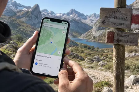
A phone indicating a "full bar" signal in an urban center may fail when thousands of devices simultaneously congest a localized cellular cell, such as at a crowded music festival or a major transit hub. Furthermore, the physical environment remains a significant hurdle. Deep mountain valleys, expansive tunnel networks, and concrete-dense urban canyons often cause signal degradation or frequent "hand-offs" between cellular towers. When a navigation application attempts to recalibrate a route during one of these "dead zones," the lack of local data can lead to a frozen interface or, more critically, a failure to provide guidance at a crucial intersection. Consequently, users are increasingly viewing the pre-downloading of maps as an essential contingency plan rather than an outdated practice.
Technical Foundations: GPS Versus Cartography
To understand why offline maps remain relevant, it is necessary to distinguish between the two primary technologies involved in mobile navigation: Global Navigation Satellite Systems (GNSS) and local cartographic data.
The GPS chip in a smartphone functions independently of the cellular network. It receives time-stamped signals from satellites to calculate the device’s precise coordinates on Earth. However, these coordinates are merely numerical data—latitude and longitude. To render this data into a meaningful experience, the device must overlay these coordinates onto a visual map.

If the map data is stored locally on the device’s internal memory, the phone can display the user’s position and provide guidance without requiring an active internet connection. The internet acts as an accelerator, providing live updates like traffic incidents or temporary road closures. While an offline map is effectively "static"—reflecting the last date of its update—it provides the stability that active, cloud-dependent navigation cannot guarantee in remote or congested environments.
Evolution of Offline Solutions: Google vs. Apple
The market response to this consumer trend has been a competitive race between the two dominant operating systems.
Google Maps has long championed the "offline area" feature, allowing users to define a specific geographic perimeter to store locally. While robust, this feature remains subject to specific limitations. According to Google’s current technical documentation, offline mode is primarily optimized for driving; users lose access to walking, cycling, and public transit routing, as well as real-time traffic data and complex route alternatives. Furthermore, contractual agreements and local licensing restrictions prevent the download of offline maps in certain international regions.
Apple Maps, conversely, significantly modernized its offline capabilities with the introduction of iOS 17. The Apple ecosystem currently allows for more comprehensive offline functionality, including step-by-step directions for multiple modes of transport—pedestrian, cyclist, and transit—alongside the ability to view business ratings and schedules. Apple’s integration also excels in user-facing management, providing clear data on the storage size of maps before download and offering automated update features to ensure that local files do not become excessively obsolete.
Alternative Navigational Paradigms
Beyond the giants of Silicon Valley, specialized applications have carved out significant market share. HERE WeGo has emerged as a preferred solution for power users, offering the ability to download entire regional maps and, crucially, the option to store these large files on external SD cards in Android devices, thereby preserving precious internal memory.
Meanwhile, applications utilizing OpenStreetMap (OSM) data—a community-driven, open-source project—have gained traction among hikers, cyclists, and off-road travelers. Because these maps are crowdsourced, they often contain granular details of rural trails and secondary roads that commercial platforms overlook. The trade-off, however, remains the variance in quality; while an urban center may be perfectly mapped, rural coverage can be inconsistent, making it a specialized rather than a general-purpose solution.
Broader Implications and Strategic Recommendations
The rise in offline map adoption carries significant implications for both mobile developers and urban planners. From a development standpoint, there is a clear mandate to improve the efficiency of cache management. Users are prioritizing applications that offer a "fail-safe" state, where the transition from online to offline is seamless and does not degrade the user experience.
From a strategic perspective, the reliance on offline maps suggests that the "all-connected" future is still an aspiration rather than a current reality. For the average traveler, the most reliable strategy remains a dual-layer approach:
- Redundancy: Always download a map area larger than the planned route.
- Verification: Test the offline functionality in "Airplane Mode" before beginning the journey to ensure that the search and routing features are functional without cellular data.
- Hardware Considerations: While offline maps reduce the battery drain associated with constant data polling, the GPS chip remains active. Users should be aware that navigation will continue to consume battery life even when the cellular radio is quiet.
A Data-Driven Outlook
The 85% growth in search interest underscores a fundamental change in how users perceive digital reliability. In 2026, the modern traveler is increasingly skeptical of the "always-on" internet promise. By prioritizing local data, users are exerting control over their navigational reliability.
As we look toward the future of transport, the industry may see a greater convergence of "hybrid" navigation models—where predictive AI models are downloaded locally to handle routing decisions that would have previously required a server-side request. Until then, the manual management of offline maps remains a foundational skill for the modern mobile user. The "offline" movement is not a regression into the past, but rather a pragmatic adaptation to the inherent vulnerabilities of global cellular infrastructure. Whether navigating a remote mountain pass or simply attempting to navigate a crowded city center during a major event, the ability to operate independently of the network is becoming a key hallmark of a sophisticated digital traveler.
