
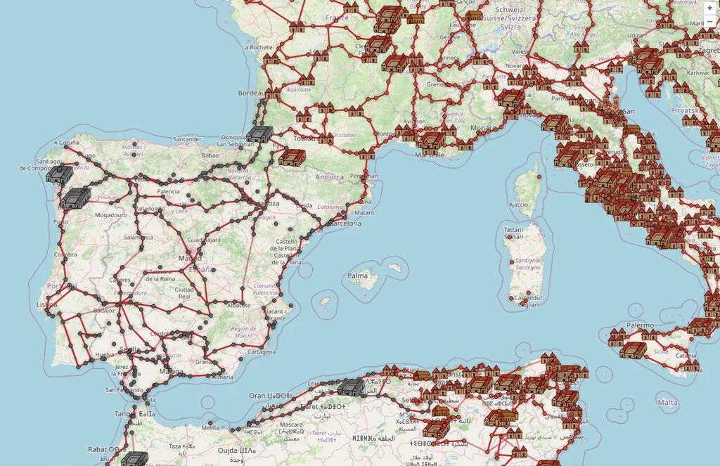

In an era dominated by instantaneous global communication and advanced satellite navigation systems, the concept of mapping a journey from two millennia ago might seem an abstract exercise. Yet, a remarkable digital platform, OmnesViae.org, has effectively resurrected the travel experience of the Roman Empire, allowing users to plot routes across its vast dominion as if using a contemporary navigation application. This innovative web-based tool provides a unique window into the logistical marvels and everyday challenges of travel in 20 B.C., translating ancient cartographic data into an accessible, interactive format that merges historical accuracy with modern geographical context.
The Roman Engineering Marvel: A Network of Power and Commerce
The Roman Empire was not merely defined by its legions or its emperors, but fundamentally by its unparalleled infrastructure, particularly its extensive network of roads. Spanning over 400,000 kilometers at its zenith, with more than 80,000 kilometers of paved roads, this system was a testament to Roman engineering prowess and strategic vision. These viae publicae (public roads) were far more than simple pathways; they were arteries vital for the empire’s survival and expansion, facilitating military movements, administrative control, trade, and communication.
Construction of these roads was a monumental undertaking, involving legions of soldiers and skilled engineers. They were meticulously planned, often in straight lines, traversing diverse and challenging terrains, from mountains to marshes. The typical Roman road featured several layers: a foundation of large stones (statumen), a layer of smaller stones and gravel (rudus), a concrete-like mixture (nucleus), and finally, a paved surface of fitted polygonal stones (pavimentum). Bridges, tunnels, and causeways were integral components, ensuring continuity across rivers and valleys. The most famous example, the Appian Way (Via Appia), begun in 312 B.C., stretched from Rome to Brundisium (modern Brindisi), showcasing the durability and scale of these constructions, many sections of which remain visible and even in use today. This sophisticated network underpinned the Pax Romana, allowing for the rapid deployment of troops to quell rebellions, the efficient transport of goods and resources, and the swift dissemination of imperial decrees via the cursus publicus (imperial postal service).
Unearthing Ancient Cartography: The Tabula Peutingeriana
The foundation for OmnesViae.org’s historical accuracy lies in one of the most extraordinary surviving artifacts of Roman cartography: the Tabula Peutingeriana, or Peutinger Map. This ancient scroll, a medieval copy of a probable Roman original dating back to the 4th century A.D. (though possibly reflecting earlier Roman sources, perhaps even from the time of Augustus), depicts the road network of the Roman Empire, parts of the Near East, and North Africa. It is a remarkable document that provides invaluable insights into the geographical knowledge and travel priorities of the Roman world.
Unlike modern topographical maps, the Peutinger Map is an itinerarium pictum – a pictorial itinerary. It is not drawn to scale in a geographical sense, but rather distorts distances and directions to emphasize routes and key locations. Cities are represented by symbols, and roads are depicted as a series of lines, focusing on connections and distances between stopping points rather than precise geographical placement. The map is divided into 11 sections and measures approximately 6.8 meters long by 0.34 meters high, illustrating a continuous journey across the known world from Britannia to India. Discovered in a library in Augsburg in 1508 by Konrad Celtes, who bequeathed it to the antiquarian Konrad Peutinger, it is currently housed in the Austrian National Library in Vienna. Its preservation through centuries is a testament to its historical significance, providing modern scholars with an unparalleled resource for understanding Roman travel, trade, and military logistics. The map details thousands of settlements, roads, rivers, and mountains, alongside distances in Roman miles, offering a granular view of the empire’s communication arteries. The painstaking effort by René Voorburg to translate this ancient, non-topographical representation into an interactive, geographically accurate digital map overlaid on contemporary terrain is central to OmnesViae.org’s appeal and utility.
OmnesViae.org: Navigating the Past with Modern Technology
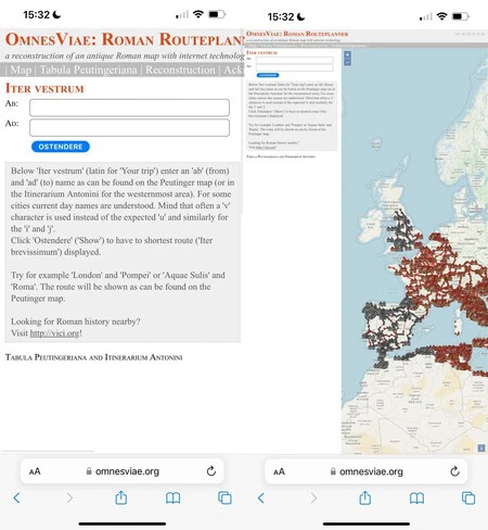
René Voorburg, a Dutch engineer, is the visionary behind OmnesViae.org. His motivation stemmed from a desire to make the ancient Roman world more tangible and accessible, particularly for those curious about the practicalities of travel in antiquity. By meticulously digitizing the information from the Peutinger Map and integrating it with modern geographical data, Voorburg has created a bridge between historical scholarship and contemporary technology. The website allows users to input modern place names, which are then translated into their Roman equivalents (e.g., Madrid becomes Miaccum, Barcelona becomes Barcenone, London becomes Londinium). The platform then calculates the most efficient route using the ancient Roman road network, overlaying it onto a modern map.
The user interface, though optimized for desktop, is remarkably functional on mobile browsers, making it a versatile tool for both casual exploration and serious historical inquiry. When a route is established, OmnesViae.org highlights the chosen path in a distinct color, typically yellow, and provides a detailed itinerary. This itinerary includes not only the sequence of ancient towns and stations (mansiones and mutationes where travelers could rest or change horses) along the route but also the distances in Roman miles and, crucially, an estimated travel time in days. This feature transforms abstract historical data into a relatable experience, allowing users to grasp the arduous nature of ancient journeys. The underlying algorithms likely consider factors such as road type, terrain, and average daily travel speeds common in the Roman era, thus offering a realistic approximation of ancient travel durations. This blend of historical fidelity and interactive design makes OmnesViae.org an invaluable resource for anyone seeking to understand the logistical realities of the Roman Empire.
A Journey Through Time: Miaccum to Barcenone (Madrid to Barcelona)
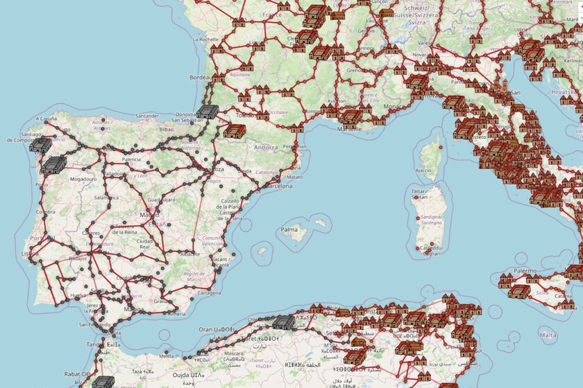
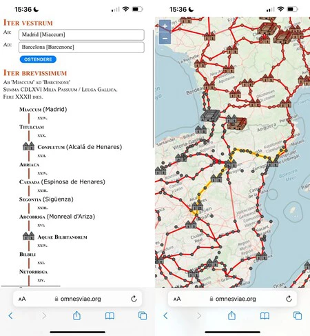
To illustrate the capabilities of OmnesViae.org, consider a hypothetical journey from modern-day Madrid to Barcelona. When inputting these cities into the platform, they are translated into their Roman counterparts: Miaccum and Barcenone, respectively. The system then calculates the most direct and efficient route along the ancient Roman roads that once crisscrossed the Iberian Peninsula. The map visually traces this route, often revealing a path that deviates significantly from modern highways, instead following ancient riverbeds, existing Roman bridges, and strategically important settlements.
The detailed itinerary provided by OmnesViae.org lists key intermediate stops. For instance, the journey from Miaccum to Barcenone would likely pass through Conplutum (modern Alcalá de Henares), a significant Roman city, before continuing towards Tarracone (Tarragona), one of the most important Roman cities in Hispania, serving as the capital of the Roman province of Hispania Citerior. Further stops might include places like Fines (Martorell), close to Barcenone. This granular level of detail not only shows the path but also educates the user about the historical geography of the region, linking ancient place names to their contemporary locations. The visual overlay of Roman roads on a modern map allows for an immediate appreciation of how much of the ancient infrastructure either underlies or has been superseded by modern development. This practical demonstration underscores the website’s ability to contextualize historical data within a familiar framework, making the past feel more immediate and understandable.
The Rigors of Roman Travel: Distances, Durations, and Daily Life
The most striking revelation from OmnesViae.org, especially when compared with modern travel, is the sheer duration of ancient journeys. For the route from Miaccum (Madrid) to Barcenone (Barcelona), the platform estimates a travel time of XXXII days, covering 466 Roman miles. Converting Roman miles to modern kilometers (one Roman mile is approximately 1,480 meters), this equates to roughly 690 kilometers. To traverse this distance in 32 days implies an average daily travel of approximately 21.5 kilometers.
This figure highlights the significant difference in travel speed compared to today. A modern navigation system like Google Maps estimates the same journey by car to take around 5 days, considering rest stops and standard driving conditions. The 27-day disparity underscores the immense advancements in transportation technology and infrastructure over two millennia. Roman travel was arduous and slow, primarily undertaken on foot, by horse, or in ox-drawn carts. The speed of travel was dictated by the pace of walking or the endurance of animals, typically averaging 20-30 kilometers per day for infantry or regular travelers. For urgent messages or imperial officials utilizing the cursus publicus, relays of fresh horses at mutationes could significantly increase speed, sometimes allowing for over 100 kilometers per day. However, such speeds were exceptional and not the norm for general travel. Travelers relied on mansiones (official roadside inns) and mutationes (relay stations for changing horses) for rest, sustenance, and fresh mounts, which were strategically spaced along major roads. The estimated 32-day journey from Miaccum to Barcenone vividly illustrates the commitment, resources, and time required for inter-provincial travel within the Roman Empire, offering a stark contrast to the modern expectation of rapid transit.
The Enduring Proverb: All Roads Truly Led to Rome
The popular adage, "All roads lead to Rome," is more than just a proverb; it is a literal truth rooted in the strategic design of the Roman road network. From a logistical and administrative perspective, the entire system was engineered to facilitate communication, control, and commerce with the imperial capital as its central nexus. Every major road, whether originating from the farthest reaches of Britannia or the eastern provinces, ultimately connected to the intricate web of routes that converged upon Rome.
This centralized design served multiple critical purposes. Militarily, it ensured that legions could be rapidly dispatched from the capital to any troubled region of the empire. Economically, it funneled goods, taxes, and resources towards Rome, consolidating its position as the empire’s commercial heart. Administratively, it allowed for the efficient flow of information, imperial decrees, and officials, reinforcing the centralized authority of the emperor. OmnesViae.org visually corroborates this historical fact. If one were to plot a route from virtually any significant Roman settlement, the path would invariably lead towards Rome, often through a series of increasingly important junction cities. This physical manifestation of centrality reflected the political and cultural dominance of Rome, making the proverb not just a metaphor for inevitability but a factual description of the empire’s logistical reality. The ability of the website to demonstrate this connectivity visually provides a powerful educational experience, transforming an abstract historical concept into a tangible, interactive reality.
Implications and Educational Value: Bridging the Past and Present
The creation of OmnesViae.org carries significant implications for historical research, education, and public engagement. For historians and archaeologists, it offers a powerful visualization tool that aids in understanding the logistical challenges and capabilities of the Roman Empire. Researchers can simulate military campaigns, analyze trade routes, or study the spread of ideas and cultures by tracing ancient journeys. The ability to precisely measure distances in Roman miles and estimate travel times provides empirical data that can support or challenge existing historical hypotheses regarding Roman mobility and infrastructure.
In an educational context, OmnesViae.org is an invaluable resource. It transforms the often-dry study of ancient geography and infrastructure into an engaging, interactive experience. Students can actively participate in historical exploration, plotting their own routes and observing the real-world implications of Roman engineering. This hands-on approach fosters a deeper understanding of the scale and sophistication of the Roman world, making history come alive in a way that static maps or textbooks cannot. Furthermore, by overlaying ancient routes onto modern maps, the tool highlights the enduring legacy of Roman infrastructure, showing how many contemporary roads still follow ancient pathways or how modern towns grew from Roman settlements. The inferred reactions from the academic community would likely be overwhelmingly positive, praising the tool for its accuracy, accessibility, and pedagogical potential.
The Future of Digital Humanities: Preserving and Exploring History
OmnesViae.org stands as a prime example of the burgeoning field of digital humanities, where technology is leveraged to preserve, analyze, and disseminate historical and cultural data. Projects like this demonstrate how digital platforms can make complex historical information accessible to a wider audience, transcending the boundaries of traditional academic research. By digitizing and interpreting historical maps and records, these initiatives not only preserve fragile ancient documents but also unlock new avenues for exploration and understanding.
The success of OmnesViae.org suggests a promising future for similar endeavors. One could envision similar digital reconstructions for other ancient civilizations with extensive road networks, such as the Inca Empire’s Qhapaq Ñan or the Persian Royal Road. Such tools could be further enriched with layers of historical data, including archaeological sites, population centers, natural resources, and even weather patterns to provide an even more comprehensive simulation of ancient life and travel. The continuous development of mapping technologies, AI, and big data analysis holds the potential to create increasingly sophisticated and immersive historical experiences. Ultimately, OmnesViae.org is more than just a curious novelty; it is a powerful testament to the enduring human fascination with the past and the innovative ways in which modern technology can illuminate and preserve our shared heritage, bridging millennia with a click of a button.
