
As the summer season approaches and millions prepare for their annual pilgrimage to vacation destinations, the logistical complexities of road travel come into sharp focus. From meticulous packing to essential vehicle maintenance, every detail is crucial for a smooth journey. Increasingly, advanced navigation applications like Waze have transcended their basic function of providing directions, evolving into indispensable tools for comprehensive trip planning and real-time optimization. This analysis delves into the multifaceted capabilities of Waze that empower travelers to navigate the "operación salida" with enhanced efficiency, safety, and cost-effectiveness, fundamentally reshaping the modern road trip experience.
The annual summer exodus represents a significant logistical challenge, with national traffic authorities bracing for peak congestion periods. Data from previous years consistently shows a surge in road travel during July and August, leading to increased traffic volume, longer journey times, and heightened accident risks. In this context, technologies that offer predictive analytics and real-time insights are no longer luxuries but necessities. Waze, with its community-driven data model, stands out by providing dynamic routing, predictive departure planning, integrated stop management, and crucial safety alerts, enabling travelers to anticipate and mitigate common travel hurdles before and during their journeys.
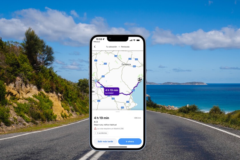
Strategic Route Selection: Beyond the Fastest Path
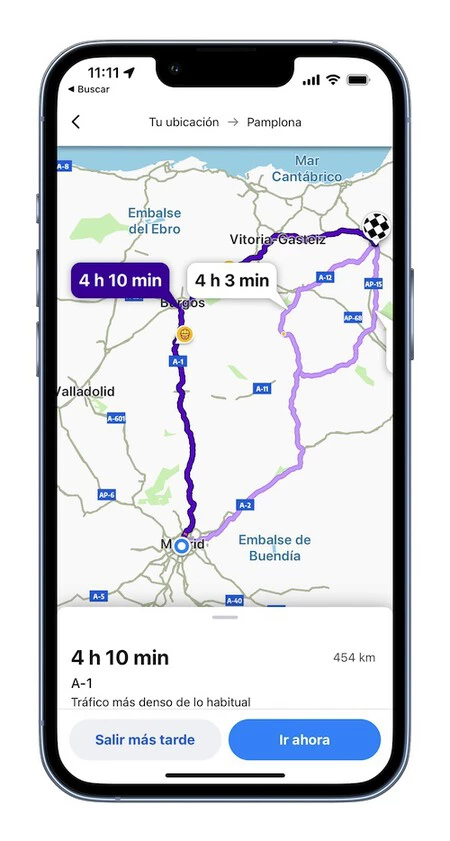
The initial step in any road trip planning involves determining the most suitable route. While Waze’s default recommendation typically prioritizes the fastest available path, often highlighted prominently on the map, a deeper dive into its routing options reveals a sophisticated decision-making process. The application continuously processes vast amounts of real-time data, including live traffic updates, reported incidents (accidents, road closures), and historical traffic patterns, to calculate estimated travel times and distances. However, experienced travelers understand that "fastest" does not always equate to "best."
Waze presents alternative routes, allowing users to visually inspect various options. This visual inspection is critical, as it provides insights into the nature of the roads – distinguishing between high-speed motorways, potentially congested national roads, or even less-traveled, scenic, but slower routes. For instance, while a shortcut through rural areas might appear faster in terms of raw time, it could involve narrower roads, lower speed limits, or less predictable driving conditions, colloquially referred to as "caminos de cabras" (goat paths). A study by the DGT (Dirección General de Tráfico) highlighted that while main arteries carry the bulk of traffic, a significant percentage of accidents occur on secondary roads, often due to unfamiliarity with the terrain or sudden changes in conditions. Waze’s ability to overlay traffic density and incident reports onto these routes empowers users to make informed choices, balancing speed with comfort, safety, and road quality preferences. This dynamic route evaluation, facilitated by a comprehensive visual interface, offers a significant advantage over static map applications.
Optimizing Departure Times: Leveraging Predictive Analytics
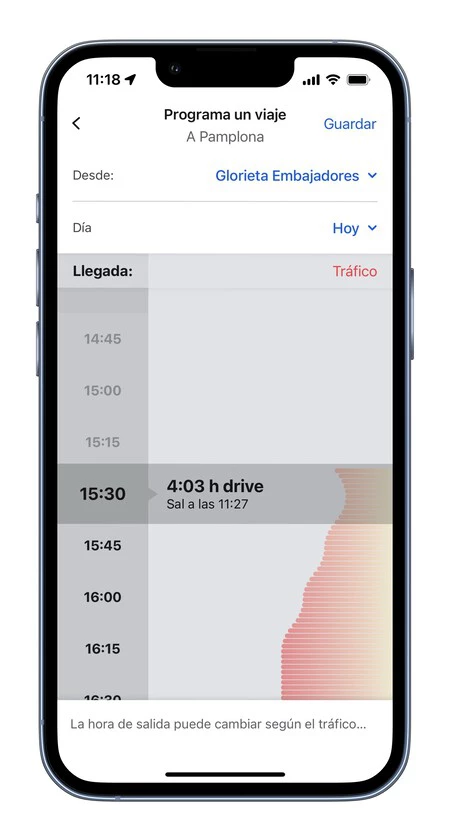
Once a preferred route is established, a critical factor for minimizing travel stress is selecting the optimal departure time. Waze offers a robust predictive analytics feature, accessible via the "Salir más tarde" (Depart later) option, which graphically illustrates how travel times fluctuate based on different departure slots. This functionality is far more sophisticated than simple guesswork. It integrates historical traffic data for specific days of the week and dates, current real-time traffic conditions, anticipated events (e.g., major concerts, festivals, or holiday weekends), and even weather forecasts to generate highly accurate predictions.
For example, departing on a Friday afternoon at the start of a long weekend will invariably encounter heavier traffic than departing early on a Tuesday morning. Waze’s algorithm accounts for these variables, presenting a clear visualization of expected journey durations throughout the day. This allows travelers to identify "sweet spots" – periods with significantly lighter traffic – potentially saving hours on a long journey. While strict adherence to these suggested times might not always be feasible due to personal commitments, the feature provides invaluable guidance, enabling users to adjust their plans to depart within a more favorable window. Industry analysts estimate that strategic departure time planning, aided by such tools, can reduce peak-time travel delays by up to 20-30% on major routes during holiday periods, translating into considerable savings in fuel and reduced driver fatigue.

Strategic Stop Planning: Enhancing Comfort and Efficiency
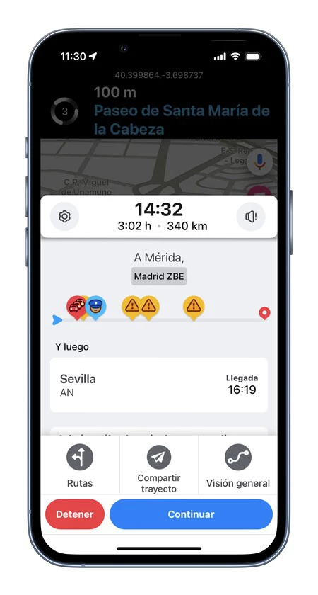
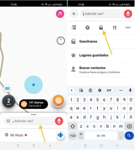
Long-distance travel necessitates regular breaks for rest, refueling, and sustenance. Health and safety guidelines universally recommend stopping every two hours for at least 15-20 minutes to combat driver fatigue, stretch, and maintain focus. Waze streamlines the integration of these "paradas técnicas" (technical stops) directly into the route planning. After inputting the primary destination, users can access the "Añadir parada" (Add stop) feature, which intuitively displays options for gas stations, restaurants, or even a general search function for points of interest along the chosen path.
This feature is particularly beneficial for multi-day trips or journeys where travelers wish to explore local attractions en route. For instance, a family traveling from Seville to Madrid might use Waze to identify a suitable lunch stop in Mérida, not only for a meal but also for a brief exploration of the city’s historical sites, transforming a utilitarian break into a mini-adventure. The application dynamically recalculates the estimated time of arrival (ETA) to include the duration of these stops, providing a more realistic and comprehensive travel itinerary. This capability promotes safer driving habits by encouraging planned breaks and enriches the travel experience by integrating discovery opportunities.
Fuel Cost Optimization: A Critical Economic Advantage
With fluctuating and often high fuel prices, managing expenditure on gasoline or diesel has become a significant concern for travelers. Waze addresses this directly with its integrated fuel price comparison tool. While it is always advisable to start a long journey with a full tank, mid-journey refueling is often inevitable, especially on return trips or extended expeditions.
When on a planned route or simply in search of fuel, users can access the "Combustible" (Fuel) button within the search interface or by tapping the gas station icon on the map. Waze then displays nearby gas stations along with their current fuel prices. A particularly intuitive feature is the color-coded system: green indicates the most affordable options, while red signifies the most expensive. This visual cue allows drivers to quickly identify cost-effective refueling points without extensive searching, potentially saving significant amounts over a long trip. Given the average cost of fuel and the volume consumed during typical holiday travel, leveraging this feature can result in substantial savings. A recent consumer report indicated that drivers using navigation apps with real-time fuel price data could save an average of 5-10% on their fuel costs per trip, an increasingly valuable benefit in the current economic climate. This functionality is a prime example of how Waze extends beyond simple navigation to offer tangible economic benefits.
Enhanced Safety: Real-time Speed Monitoring and Alerts
Driver behavior, particularly adherence to speed limits, is paramount for road safety. Over-speeding is a leading cause of accidents and can result in costly fines. Waze integrates a highly effective speedometer feature that serves as a constant reminder of legal speed limits and the vehicle’s current velocity. Unlike a car’s built-in speedometer, which may have a slight calibration variance, Waze’s GPS-based speed reading is often more accurate.
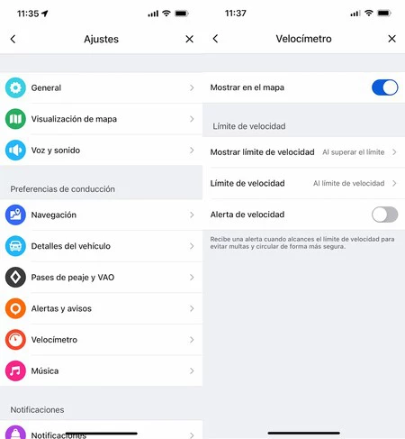
Users can activate this feature by navigating to "Mi Waze" > "Ajustes" (Settings) > "Velocímetro" (Speedometer) and enabling "Mostrar en el mapa" (Show on map). Crucially, the "Límites de seguridad" (Safety limits) setting allows users to configure alerts for exceeding the speed limit. When "Al superar el límite" (When exceeding the limit) is selected, the interface changes, often displaying the speed in red or with an explicit warning, providing an immediate visual cue to the driver. Additionally, activating the "Alerta de velocidad" (Speed alert) toggle can provide an audible warning, further reinforcing safe driving practices. This proactive alert system significantly reduces the likelihood of unintentional speeding, contributing directly to road safety and helping drivers avoid penalties. Traffic safety organizations frequently endorse such in-app features as supplementary aids to responsible driving.

Community-Driven Incident Reporting: Unparalleled Real-time Alerts
Perhaps Waze’s most distinguishing and celebrated feature is its community-driven incident reporting system. This collective intelligence model provides unparalleled real-time alerts for a wide array of road conditions and hazards. While many navigation apps offer traffic data, Waze’s strength lies in its active user base, who continually report everything from fixed and mobile speed cameras to police presence, road hazards, accidents, and even potholes.
Configuring these alerts is straightforward: within "Ajustes" > "Alertas y avisos" (Alerts and warnings), users can customize which types of notifications they wish to receive. This includes "radares de velocidad" (speed cameras), "radares de semáforo" (red light cameras), "policía" (police), "atascos" (traffic jams), and "peligros en la vía" (road hazards). The immediate dissemination of these user-reported incidents allows other Waze users to adjust their speed, choose alternative routes, or exercise heightened caution well in advance. This collaborative approach creates a dynamic, self-updating map that often provides more granular and timely information than traditional traffic reporting services. The ability to anticipate hidden speed traps or sudden obstacles can prevent accidents, save lives, and significantly reduce travel anxiety.
Seamless Journey Sharing: Enhancing Peace of Mind
In an era of constant connectivity, keeping loved ones informed about travel progress is a common courtesy and often a safety imperative. Waze simplifies this by integrating a "Compartir trayecto" (Share journey) feature, allowing travelers to send their real-time location and estimated time of arrival (ETA) to selected contacts. This eliminates the need for frequent manual updates or "check-in" calls.
Accessible directly from the journey information panel, this button opens a menu with various sharing options, including popular messaging apps like WhatsApp, email, or simply copying a link that can be pasted anywhere. Recipients can then view the traveler’s live progress on a map, understanding exactly where they are and when they are expected to arrive. This feature offers immense peace of mind, particularly for solo travelers or families with children, ensuring that designated contacts are always aware of the journey’s status without requiring active communication from the driver. It transforms the traditional "avisa cuando llegues" (let me know when you arrive) into an automated, real-time safety net.
Broader Impact and Implications for Modern Travel
The comprehensive suite of features offered by Waze has profound implications for modern road travel. Beyond individual convenience, these tools contribute to broader societal benefits:
- Enhanced Road Safety: By providing real-time alerts for hazards, speed limits, and incident reports, Waze actively promotes safer driving habits and helps prevent accidents. The community reporting model means that warnings for unexpected dangers are disseminated almost instantly.
- Increased Efficiency and Reduced Congestion: Predictive routing and optimal departure time suggestions help distribute traffic more evenly, reducing peak-hour congestion on major routes. This leads to shorter travel times and less time spent idling in traffic, which also has environmental benefits in terms of reduced emissions.
- Economic Benefits: Fuel price comparisons offer tangible savings for drivers, while efficient routing can minimize vehicle wear and tear. Reduced accident rates also lead to lower insurance costs and healthcare expenditures.
- Empowerment of Travelers: Waze shifts the power dynamic by providing drivers with unprecedented access to information, enabling them to make more informed decisions about their routes, stops, and driving behavior.
- Community Engagement: The platform thrives on user contributions, fostering a sense of community among drivers who actively help each other navigate safely and efficiently. This collaborative model is a testament to the power of collective intelligence.
While the reliance on navigation technology is growing, it is important to remember that these tools are aids, not replacements for attentive and responsible driving. The occasional "goat path" anomaly or the need for a driver’s judgment to override a less-than-ideal suggested detour highlights the ongoing interplay between technology and human decision-making. Nevertheless, Waze’s continuous evolution, driven by its vast user base and sophisticated algorithms, positions it as a vanguard in the ongoing effort to make summer road trips, and indeed all journeys, safer, more efficient, and more enjoyable for everyone. As millions embark on their summer adventures, advanced navigation technology will undoubtedly play a pivotal role in ensuring their smooth arrival.
