
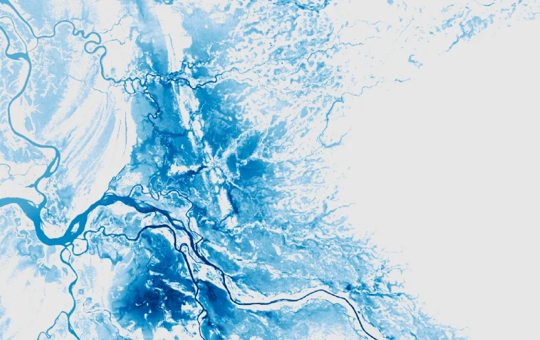

In a significant move to bolster national disaster management capabilities, Iceye, the global leader in Synthetic Aperture Radar (SAR) satellite technology, and KT SAT, South Korea’s premier satellite service provider, have finalized a strategic partnership. This collaboration marks the inaugural deployment of Iceye’s advanced Earth observation solutions within the South Korean market, aiming to provide government and commercial entities with unprecedented real-time intelligence regarding environmental hazards. The agreement, announced on Thursday, establishes a framework where KT SAT will integrate Iceye’s high-resolution SAR data into a comprehensive suite of Geographic Information System (GIS)-ready solutions, specifically targeting flood monitoring and land subsidence detection.
The partnership arrives at a critical juncture for South Korea, a nation that has increasingly faced the devastating impacts of extreme weather events. By combining Iceye’s world-class satellite constellation with KT SAT’s deep-rooted local expertise and infrastructure, the two companies intend to transform how the country prepares for, responds to, and recovers from natural disasters. Central to this initiative is the deployment of Iceye’s Flood Rapid Impact solution, which will be utilized by the Korean government to provide near-real-time situational awareness during the annual monsoon season, a period historically characterized by heavy rainfall and significant urban and rural flooding.
Technical Foundation and the Power of SAR Technology
The core of this partnership lies in the unique capabilities of Synthetic Aperture Radar (SAR) technology. Unlike traditional optical satellites, which rely on sunlight and clear skies to capture images, SAR sensors emit their own microwave signals and measure the reflections from the Earth’s surface. This allows Iceye’s satellites to "see" through clouds, smoke, and volcanic ash, and to operate with equal effectiveness during the day or the middle of the night.
For a country like South Korea, where heavy cloud cover and torrential downpours are the hallmarks of the monsoon season, optical imagery is often rendered useless at the exact moment disaster strikes. SAR technology overcomes this limitation, providing emergency responders with a "god’s eye view" of the ground even in the midst of a typhoon or a persistent rainstorm. The Iceye constellation, which is the largest of its kind globally, offers high-frequency revisit rates, meaning the satellites pass over the same location multiple times a day. This frequency is essential for monitoring the rapid progression of floodwaters and providing the temporal resolution necessary for effective emergency management.
Addressing South Korea’s Climate Vulnerability
South Korea’s geography and climate make it particularly susceptible to water-related disasters. The "Jangma," or the summer monsoon season, typically accounts for more than half of the country’s annual precipitation. In recent years, the intensity of these storms has escalated, a trend climate scientists attribute to rising global temperatures.
In August 2022, Seoul experienced its heaviest rainfall in over a century, with some districts receiving over 140mm of rain per hour. The resulting flash floods submerged subway stations, destroyed thousands of vehicles, and led to tragic loss of life. Such events have placed immense pressure on the South Korean government to upgrade its disaster monitoring infrastructure. The integration of Iceye’s Flood Rapid Impact solution is a direct response to this need. The system provides not just images, but actionable data, including flood extent and depth estimates, which are crucial for identifying trapped populations and prioritizing the deployment of rescue teams.
Beyond flooding, the partnership will also focus on land subsidence monitoring. As South Korea continues its rapid urbanization and infrastructure development, monitoring the stability of the ground is paramount. Land subsidence—the gradual settling or sudden sinking of the Earth’s surface—can be caused by groundwater extraction, underground construction, or mining. Iceye’s SAR data can detect millimetric changes in ground elevation over time, allowing city planners and engineers to identify potential sinkholes or structural risks before they lead to catastrophic failures in buildings, bridges, or tunnels.
A Strategic Shift for KT SAT
For KT SAT, a subsidiary of the telecommunications giant KT Corporation, this partnership represents a strategic evolution in its business model. Historically known for its communication satellite fleet, including the Koreasat series, KT SAT is aggressively expanding its portfolio into the Earth observation and data services sector. By partnering with Iceye, KT SAT positions itself as a central hub for high-value geospatial intelligence in Northeast Asia.
The collaboration allows KT SAT to offer "GIS-ready" data, which means the raw satellite imagery is processed, calibrated, and formatted so that it can be immediately integrated into existing government and corporate software systems. This reduces the technical barrier for local agencies, allowing them to focus on decision-making rather than data processing.
Joowhan Lee, Senior Sales Manager at KT SAT, emphasized the importance of this real-time capability during the announcement. "Iceye is positioned to become a key provider of real-time intelligence during South Korea’s most severe flood events," Lee stated. "By combining our satellite capabilities with KT SAT’s local expertise, we can help organizations make faster, more informed decisions when every minute matters."
Chronology and Global Context
The entry of Iceye into the South Korean market follows a pattern of rapid global expansion for the Finnish-based company. Founded in 2014, Iceye has quickly disrupted the Earth observation industry by launching "NewSpace" small satellites that provide capabilities previously reserved for much larger, more expensive government-funded spacecraft.
- 2018: Iceye launches its first SAR satellite, becoming the first company to successfully operate a SAR sensor on a satellite weighing less than 100kg.
- 2021-2023: The company expands its constellation to over 20 satellites, enabling hourly revisit rates in some parts of the world.
- 2024: Iceye demonstrates the efficacy of its flood monitoring during major events in Australia and the United States, providing insurance companies and governments with rapid loss assessments.
- 2025-2026: Iceye focuses on the Asia-Pacific region, identifying South Korea and Japan as high-priority markets due to their vulnerability to typhoons and seismic activity.
The image of Iceye’s monitoring of Cyclone Narelle in Australia serves as a blueprint for what the company intends to achieve in Korea. During that event, Iceye provided continuous updates on flood levels across vast, remote areas, allowing authorities to manage resources across a massive geographical footprint that would have been impossible to monitor via ground-based sensors alone.
Broader Implications for the Public and Private Sectors
The implications of this partnership extend far beyond immediate disaster response. The data generated through this collaboration will have significant long-term value for various sectors:
1. Insurance and Financial Services
The insurance industry is one of the primary beneficiaries of high-resolution SAR data. Traditionally, claims adjusters must wait for floodwaters to recede before conducting manual inspections. Iceye’s data allows for "parametric insurance" models, where payouts are triggered automatically based on verified flood depth and extent data. This speeds up the recovery process for homeowners and businesses and reduces the administrative costs for insurers.
2. Environmental and Resilience Planning
Local governments can use historical flood data to refine their flood maps and improve urban drainage systems. By understanding exactly where water accumulates during extreme rain events, planners can make data-driven decisions about where to build—and where not to build—future infrastructure.
3. Supply Chain and Logistics
Commercial organizations with large physical footprints, such as manufacturing plants or logistics hubs, can use land subsidence and flood data to protect their assets. In South Korea’s high-tech industrial corridors, even minor flooding can cause millions of dollars in damage to sensitive equipment and disrupt global supply chains.
4. National Security and Public Safety
The ability to monitor the country’s borders and coastal waters regardless of weather conditions provides an added layer of national security. While the primary focus of this agreement is civil and environmental, the dual-use nature of SAR technology enhances the overall situational awareness of the state.
Official Responses and Market Analysis
Industry analysts view this partnership as a testament to the maturing "Space 2.0" economy. Governments are increasingly moving away from owning and operating their own massive satellite constellations in favor of purchasing "data-as-a-service" from specialized private providers like Iceye.
Official responses from the South Korean Ministry of Interior and Safety have been positive, noting that the integration of satellite data into the National Disaster Management System (NDMS) is a priority for the current administration. The goal is to create a "Digital Twin" of the nation, where real-time satellite feeds are layered over 3D maps to simulate and predict the impact of various disaster scenarios.
The partnership also underscores the competitive landscape of the satellite industry in Asia. With South Korea’s own domestic satellite program, including the KOMPSAT series, the inclusion of Iceye’s SAR data suggests a "multi-source" strategy, where the government seeks to combine domestic assets with the most advanced international commercial capabilities to ensure redundancy and high-resolution coverage.
Conclusion and Future Outlook
The strategic partnership between Iceye and KT SAT represents a significant milestone in South Korea’s journey toward becoming a more climate-resilient nation. As the frequency and intensity of natural disasters continue to rise, the ability to monitor the Earth’s surface in real-time, through clouds and darkness, is no longer a luxury but a necessity for modern governance.
In the coming months, the focus will shift to the operational integration of these data streams. Training programs for local government officials and emergency responders are expected to commence ahead of the next monsoon season. Furthermore, the partners are likely to explore additional applications, such as maritime monitoring and agricultural assessment, which could further broaden the scope of their collaboration.
By bridging the gap between cutting-edge space technology and local operational needs, Iceye and KT SAT are setting a new standard for disaster management in the Asia-Pacific region. As the first deployment of Iceye Solutions in South Korea, this agreement is likely just the beginning of a long-term shift toward data-driven environmental stewardship on the Korean Peninsula. For the citizens of South Korea, this means a future where the next "once-in-a-century" storm is met with a response that is faster, smarter, and more effective than ever before.
