
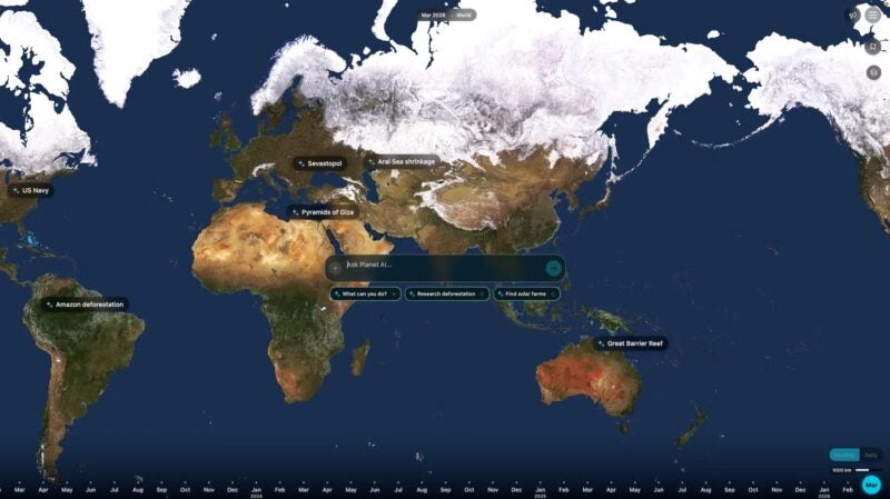
In a significant leap for the Earth observation industry, Planet Labs PBC has announced the development of a pioneering agentic AI geospatial query tool designed to bridge the gap between complex satellite data and non-technical decision-makers. This new capability allows users to interact with Planet’s massive imagery archive using natural language, enabling them to ask sophisticated questions such as “Where are new construction sites appearing in Florida?” and receive immediate, analyzed results. By moving beyond the traditional requirements of geospatial expertise, Planet aims to democratize access to orbital insights, transforming how industries from insurance to urban planning monitor the world’s physical changes.
The tool represents a shift from passive data provision to active, intelligent analysis. Unlike standard search-and-retrieval systems, the agentic AI is designed to autonomously search Planet’s vast archive, identify specific geographic features that match a user’s query, and highlight those findings on an interactive map. Beyond mere identification, the agent possesses the reasoning capability to analyze sites over time, interpret visual nuances—such as the difference between land clearing and active building—and compile the findings into a comprehensive, shareable report complete with embedded satellite imagery.
The Mechanics of Agentic AI in Earth Observation
The core of this innovation lies in the concept of "agentic" AI. While traditional AI models might classify an image or predict a single outcome, agentic systems are designed to pursue goals by planning and executing a series of complex tasks. In the context of geospatial intelligence, this means the AI does not just respond to a command; it understands the intent behind a query and determines the necessary steps to fulfill it.
When a user asks about construction trends in a specific region, the agent initiates a multi-step workflow. First, it identifies the relevant geographic boundaries and timeframes. Second, it pulls multi-temporal imagery from Planet’s Dove and SkySat constellations. Third, it applies computer vision algorithms to detect changes in land use. Finally, it synthesizes this data into a human-readable format. This automated process bypasses the manual labor of downloading tiles, calibrating imagery, and performing manual change detection—a workflow that previously required specialized software and hours of human effort.
The feature is currently in a private beta phase, as Planet refines the accuracy of its models and the fluidity of the user interface. This controlled rollout allows the company to gather feedback from high-stakes users while ensuring the AI’s interpretations remain grounded in factual, high-resolution data.
Historical Context and the Rise of GeoAI
The development of this AI tool is the culmination of over a decade of technological evolution at Planet. Founded in 2010 by former NASA scientists, Planet’s original mission was to "image the whole world every day, making change visible, accessible, and actionable." To achieve this, the company deployed the world’s largest constellation of Earth-imaging satellites, creating a unique historical record of the planet’s surface.
However, as the volume of data grew into the petabyte scale, the challenge shifted from data collection to data utilization. The "Planetary Intelligence" strategy, which Planet has championed in recent years, addresses the reality that most organizations lack the "geospatial engineering" departments necessary to process raw satellite feeds. The industry at large has seen a move toward "GeoAI"—the intersection of geographic information systems (GIS) and artificial intelligence.
In recent years, Planet has bolstered its AI capabilities through strategic acquisitions and partnerships. The 2023 acquisition of Sinergise, the developer behind the Sentinel Hub, was a pivotal move to streamline how users access and process data in the cloud. Similarly, the integration of Salo Sciences’ technology allowed Planet to offer sophisticated forest monitoring and carbon stock assessments. The agentic AI query tool is the next logical step in this evolution, moving the interface from "code-first" to "language-first."
Supporting Data and Market Projections
The demand for rapid geospatial insights is reflected in the explosive growth of the global geospatial analytics market. According to industry reports, the market was valued at approximately $70 billion in 2022 and is projected to reach nearly $200 billion by 2030, growing at a CAGR of over 13%. This growth is driven by the increasing need for real-time monitoring in environmental management, defense, and commercial supply chains.
Planet’s internal data highlights the efficiency gains promised by the new AI tool. Traditional geospatial processing workflows for large-scale monitoring projects can take anywhere from three to ten days, depending on the complexity of the atmospheric corrections and the volume of imagery. Planet’s manager of growth marketing campaigns, Mariah Hauck, noted in a recent company communication that agentic AI can compress these decision loops into minutes. This represents a time-reduction factor of over 90%, a critical advantage for organizations responding to fast-moving events like natural disasters or supply chain disruptions.
Official Responses and Strategic Vision
Planet’s leadership views the agentic AI tool as a cornerstone of their broader "Planetary Intelligence" framework. This framework aims to integrate AI across the entire value chain, from edge computing onboard the satellites to deep-learning models trained on the company’s comprehensive imagery archive.
"By automating complex geospatial processing that once took days or weeks, Agentic AI compresses decision loops into minutes," wrote Mariah Hauck in the company’s May 21 technical brief. "This capability allows organizations to understand and respond to our changing planet in near-real time, and transition from reactive monitoring to proactive management."
The company emphasizes that this tool is specifically designed for stakeholders who do not have a geospatial background. This includes insurance adjusters assessing storm damage, infrastructure managers overseeing remote pipelines, and civil government officials monitoring urban sprawl. By removing the technical barrier to entry, Planet is positioning itself not just as a satellite operator, but as a critical intelligence provider for the global economy.
Broader Impact and Industry Implications
The implications of agentic AI in Earth observation extend far beyond convenience. In the realm of environmental, social, and corporate governance (ESG), the ability to query global data in real-time could revolutionize transparency. For example, a non-governmental organization (NGO) could query the AI to find instances of illegal mining in protected rainforests across the Amazon basin, receiving a documented report in the time it takes to brew a cup of coffee.
In the financial sector, the tool offers a competitive edge for commodity traders and hedge funds. By querying the AI for changes in port activity or crop health across entire continents, analysts can gain insights into global supply chains before they are reflected in traditional economic reports.
However, the transition to AI-driven geospatial analysis also brings challenges. The industry must grapple with the "black box" nature of some AI models, ensuring that the automated reports are verifiable and free from "hallucinations"—a phenomenon where AI generates plausible but incorrect information. Planet’s approach of embedding the actual satellite imagery within the AI-generated reports is a direct attempt to provide a "ground truth" that users can verify visually.
Chronology of Geospatial Intelligence Milestones
- 2010: Planet Labs (now Planet) is founded with the goal of daily global imaging.
- 2017: Planet completes its goal of imaging the entire Earth’s landmass daily.
- 2021: Planet goes public via SPAC, signaling a shift toward commercial scaling.
- 2022: The company begins emphasizing "Planetary Intelligence," moving from raw imagery to data insights.
- 2023: Strategic acquisitions (Sinergise) focus on cloud-native data processing.
- May 2024: Planet announces the agentic AI geospatial query tool and enters private beta.
Future Outlook
As Planet moves toward a full public release of its agentic AI features, the focus will likely shift toward "edge" integration. This involves running AI models directly on satellites, allowing the spacecraft to identify significant events—such as the start of a forest fire or a ship in distress—and prioritize that data for immediate downlink.
The integration of natural language processing (NLP) with orbital sensors marks the beginning of a new era where the Earth is no longer just a subject of photography, but a searchable database. For Planet, the mission is clear: to provide the "operating system" for the planet, where any user can ask a question about the world and receive a data-backed answer in real-time. This democratization of space-based intelligence is poised to redefine how humanity manages its resources and responds to the challenges of a rapidly changing climate.
